If you are seeing this in a mobile device use it in horizontal position
Object 2024 YR4
Objeto 2024 YR4
Summary
Todo
- Orbit
Órbita
- Encounters
Encuentros
- Risk
Riesgo
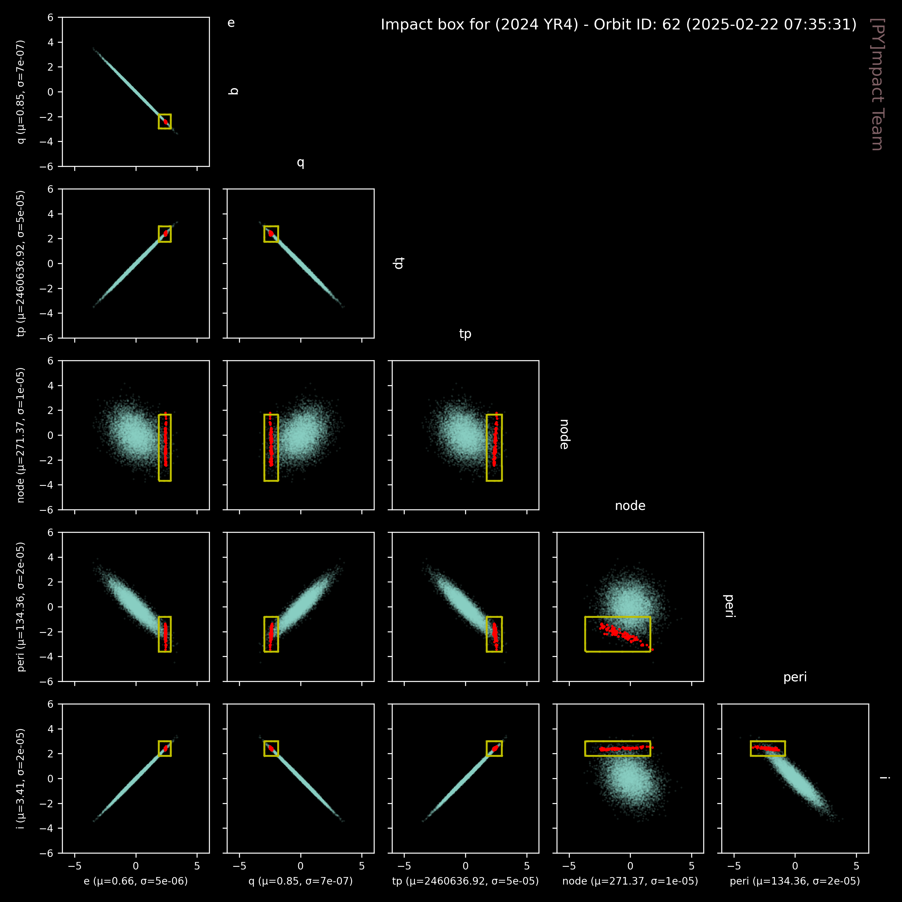
Orbital properties (orbit 62)
| Orbital elements |
| Eccentricity | 0.661551 ± 4.83e-6 |
| Semi-major axis [au] | 2.51589 ± 3.38e-5 |
| Perihelion distance [au] | 0.8515000 ± 7.05e-7 |
| Inclination; angle with respect to x-y ecliptic plane [deg] | 3.40818 ± 1.77e-5 |
| Longitude of the ascending node [deg] | 271.365616 ± 9.62e-6 |
| Argument of perihelion [deg] | 134.36136 ± 2.10e-5 |
| Mean anomaly [deg] | 40.4022 ± 8.28e-4 |
| Time of perihelion passage [TDB] | 2460636.91759 ± 5.34e-5 |
| Sidereal orbital period [d] | 1457.59 ± 2.94e-2 |
| Mean motion [deg/d] | 0.246984 ± 4.98e-6 |
| Aphelion distance [au] | 4.18027 ± 5.62e-5 |
Orbital corner plot

Countdown to next encounter (potential impact) of 2024 YR4 (orbit 62)
| Impact conditions in 2032-12-22T14:09:36.000 |
| Orbit number |
62 [2025-02-22T07:35:31] |
| Impact probability1 | 0.36% ± 0.03% |
| Date of impact | 2032-12-22 |
| Time of impact | 13:57:47 UTC [13:56:27, 14:17:02] |
| Impact centroid | lon = -1.3e+1o, lat = 1.61o |
| Impact trail | ini: [-9.6e+1o,6.88o], end: [87.93o,19.85o] |
| Impact speed | 17.00 km/s [16.89, 17.37] |
| Zenithal angle of impact3 | 49.12o [10.54, 103.68] |
- Probability computed by [PY]mpact Team. See our scientific products for details.
- Dates and geodetic coordinates are calculated for the minimum, median and maximum longitude in the impact trail.
- Impact speed and zenithal angle is calculated for the median value and the 5th and 95th percentiles.
|
Georisk for 2024 YR4
Principal municipalities in the core area (distance < 10.0 km)
| Municipality |
Distance to trail (km) |
Population |
| SAN MARTÍN, META |
8.00 |
22299 |
| GRANADA, META |
9.12 |
63408 |
Total affected (including rural and urban): 91887
Principal municipalities in the risk area (distance < 50.0 km)
| Municipality |
Distance to trail (km) |
Population |
| SAN MARTÍN, META |
8.00 |
22299 |
| GRANADA, META |
9.12 |
63408 |
| FUENTE DE ORO, META |
17.11 |
10607 |
| CASTILLA LA NUEVA, META |
22.17 |
12533 |
| GUAMAL, META |
26.46 |
13667 |
| PURIFICACIÓN, TOLIMA |
30.33 |
21826 |
| ACACÍAS, META |
38.64 |
72796 |
| SALDAÑA, TOLIMA |
41.86 |
13832 |
| GUAMO, TOLIMA |
43.91 |
30061 |
| NATAGAIMA, TOLIMA |
48.12 |
13703 |
| ESPINAL, TOLIMA |
49.06 |
66726 |
| MELGAR, TOLIMA |
49.47 |
32833 |
Total affected (including rural and urban): 504538
Principal municipalities in the shattering area (distance < 100.0 km)
| Municipality |
Distance to trail (km) |
Population |
| SAN MARTÍN, META |
8.00 |
22299 |
| GRANADA, META |
9.12 |
63408 |
| FUENTE DE ORO, META |
17.11 |
10607 |
| CASTILLA LA NUEVA, META |
22.17 |
12533 |
| GUAMAL, META |
26.46 |
13667 |
| PURIFICACIÓN, TOLIMA |
30.33 |
21826 |
| ACACÍAS, META |
38.64 |
72796 |
| SALDAÑA, TOLIMA |
41.86 |
13832 |
| GUAMO, TOLIMA |
43.91 |
30061 |
| NATAGAIMA, TOLIMA |
48.12 |
13703 |
| ESPINAL, TOLIMA |
49.06 |
66726 |
| MELGAR, TOLIMA |
49.47 |
32833 |
| VILLAVICENCIO, META |
55.59 |
444291 |
| VISTAHERMOSA, META |
55.99 |
12474 |
| COYAIMA, TOLIMA |
57.15 |
18489 |
| FLANDES, TOLIMA |
59.32 |
26027 |
| PUERTO LÓPEZ, META |
61.48 |
25612 |
| SAN LUIS, TOLIMA |
62.04 |
11745 |
| GIRARDOT, CUNDINAMARCA |
62.74 |
93858 |
| ORTEGA, TOLIMA |
63.26 |
28869 |
| FUSAGASUGÁ, CUNDINAMARCA |
67.91 |
130879 |
| AGUA DE DIOS, CUNDINAMARCA |
68.27 |
10103 |
| RESTREPO, META |
71.01 |
16750 |
| SILVANIA, CUNDINAMARCA |
72.43 |
21375 |
| CUMARAL, META |
73.28 |
19669 |
| VIOTÁ, CUNDINAMARCA |
76.99 |
12300 |
| TOCAIMA, CUNDINAMARCA |
77.70 |
13357 |
| ATACO, TOLIMA |
80.12 |
17156 |
| CÁQUEZA, CUNDINAMARCA |
81.46 |
15387 |
| ROVIRA, TOLIMA |
81.81 |
18814 |
| AIPE, HUILA |
85.64 |
13064 |
| SIBATÉ, CUNDINAMARCA |
86.73 |
31317 |
| CHAPARRAL, TOLIMA |
88.94 |
40889 |
| SAN ANTONIO, TOLIMA |
90.43 |
10341 |
| ANAPOIMA, CUNDINAMARCA |
90.44 |
12325 |
| FÓMEQUE, CUNDINAMARCA |
91.15 |
10646 |
| TELLO, HUILA |
91.76 |
10008 |
| EL COLEGIO, CUNDINAMARCA |
93.37 |
22541 |
| IBAGUÉ, TOLIMA |
93.85 |
492726 |
| CHOACHÍ, CUNDINAMARCA |
95.27 |
10222 |
| SOACHA, CUNDINAMARCA |
96.85 |
661655 |
| PUERTO GAITÁN, META |
98.27 |
32358 |
| SAN ANTONIO DEL TEQUENDAMA, CUNDINAMARCA |
98.89 |
10164 |
| LA MESA, CUNDINAMARCA |
98.91 |
29025 |
Total affected (including rural and urban): 3003814
Impact trail for 2024 YR4 in 2032-12-22T14:09:36.000 (orbit 62)